Fjord Trail South
Watch this video showing the proposed route from Dockside in Cold Spring to Breakneck Ridge along the edge of the tracks. Then click through the slides below to learn why this section of the proposed Fjord Trail is not only impractical, but would be highly destructive to the environment and the scenic views. The drawings in the slides are from HHFT documents obtained by Freedom of Information Law requests.
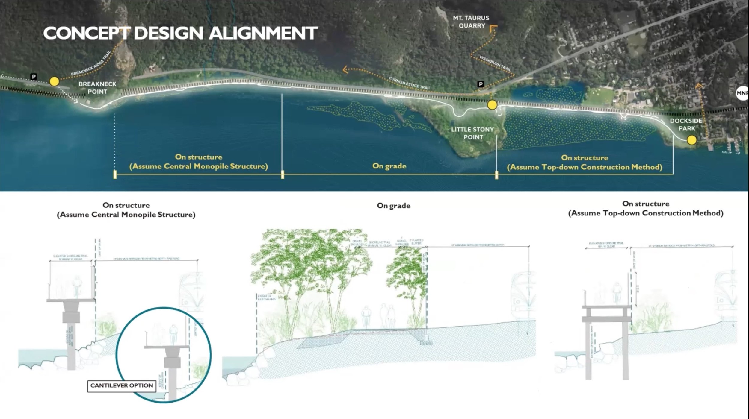
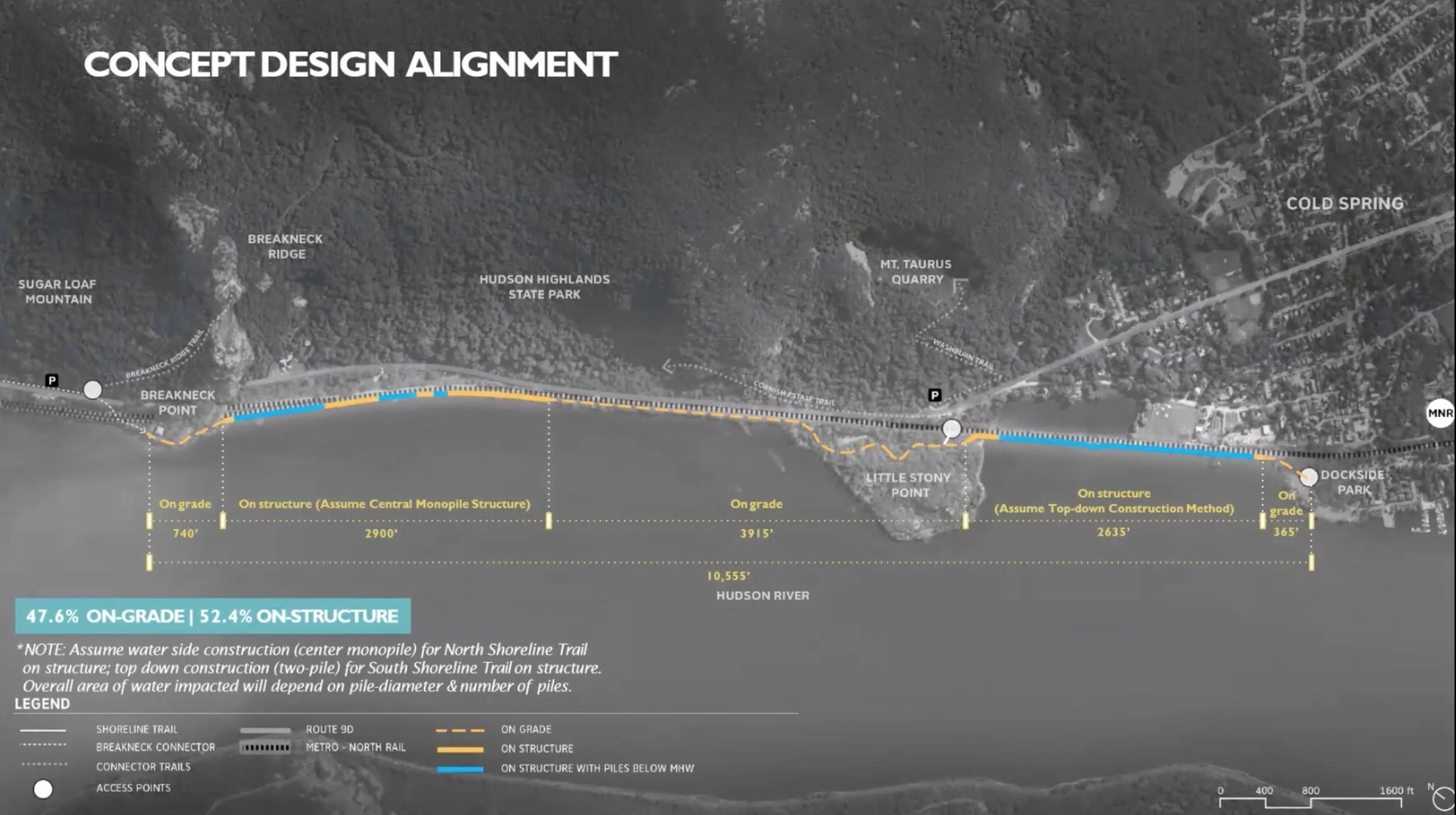
Scenic Hudson's proposed "Shoreline Trail" would run along the river's edge next to the train tracks from Dockside to Little Stony Point, and then from Little Stony Point to Breakneck Ridge. Click > above to scroll through the presentation.

Metro-North requires the trail to be at least 25 feet from the center of the nearest track. As you'll see in the next few slides, there isn't enough room for long sections of the route.

This view is at the north end of Mayor's Park in Cold Spring. The green line is 25 feet from the center of the nearest track, so the trail would need to be below the green line, i.e. over the river, to meet Metro-North's setback requirements.

This view is slightly further north, approaching Little Stony Point. On the left is a Metro-North utility hut that requires an additional 6 feet of clearance.
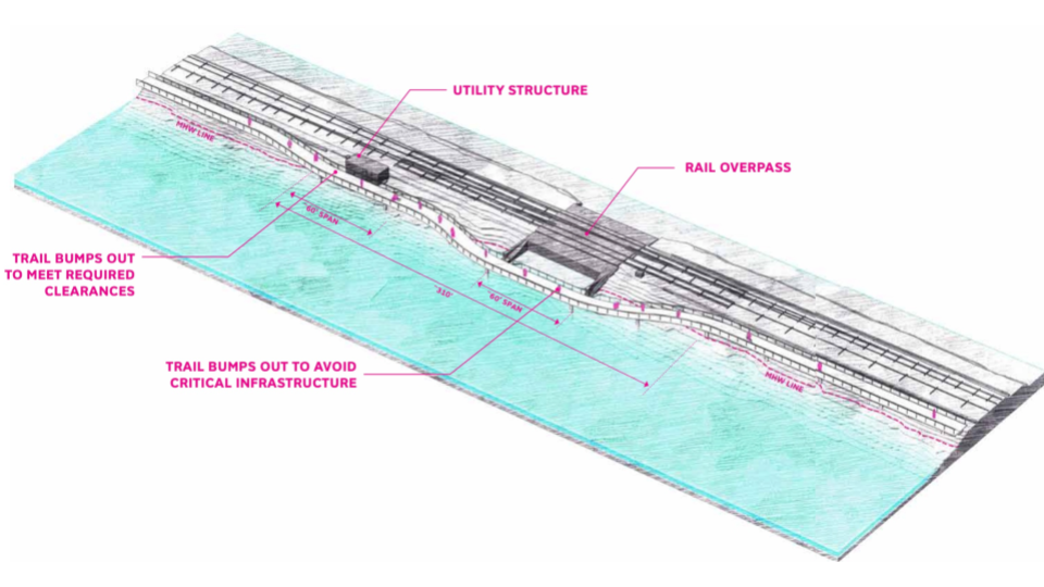
This diagram of the same section shows how Scenic Hudson's designers propose to dodge infrastructure by building out into the water.

Things are slightly wider on this section just north of Little Stony Point, but what you see here really is the “best case” along the entire shoreline trail.

The shoreline narrows as you approach Breakneck Ridge. This is representative of the long stretch as you approach the tunnel. Remember that everything has to be below the green line.
Here’s another bump-out sketch, this one north of Little Stony Point where there's a Metro-North communications box. In the diagram, notice how narrow the trail is, with barely room for an adult with a child, and a cyclist.
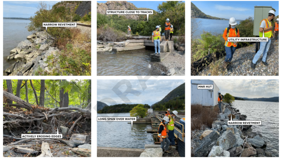
These pictures show a few of the most challenging sections up close. The workers are clearly having a hard time seeing how or why anyone would build a trail here.

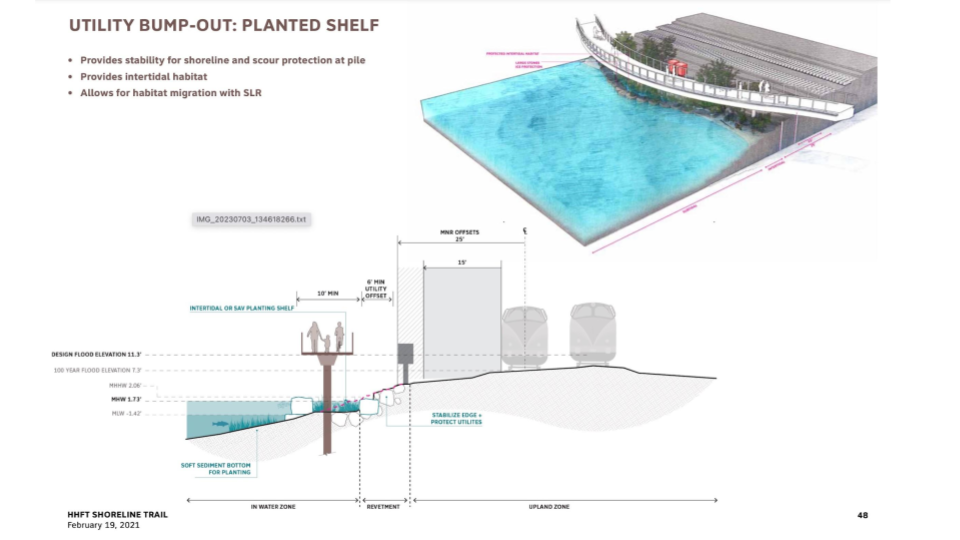
The trail must be out of "mean high water," shown by the dotted red vertical line, to the greatest extent possible, i.e. everything must be to the right of the line. But Metro-North wants everything as far from the tracks as possible. For long stretches, there just isn't room.

Metro-North might allow the trail to be closer at specific "pinch points." Here, to stay clear of mean high water the trail is now 15 feet from trains potentially traveling at 80 miles per hour.

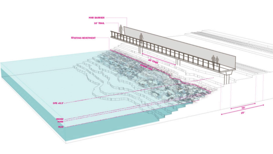
This diagram is from one of the widest sections of shoreline, north of Little Stony Point, but you can see they have to remove most of the existing vegetation, which they’ve indicated by showing it in red.
This rendering from an internal design presentation shows the trail from a different vantage point. The width of the trail is 10 feet, and it's only 15 feet from the tracks and barely above mean high water.

Here, they’re suggesting they can minimize vegetation loss by weaving through existing tree clusters. This sounds hopeful, but wait...
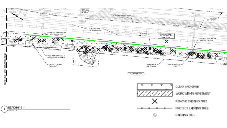
The X means "remove existing tree," and “clear and grub,” means remove all existing vegetation and remove the roots. According to this schematic, most of the dense vegetation we saw along the edge of the river would be removed.

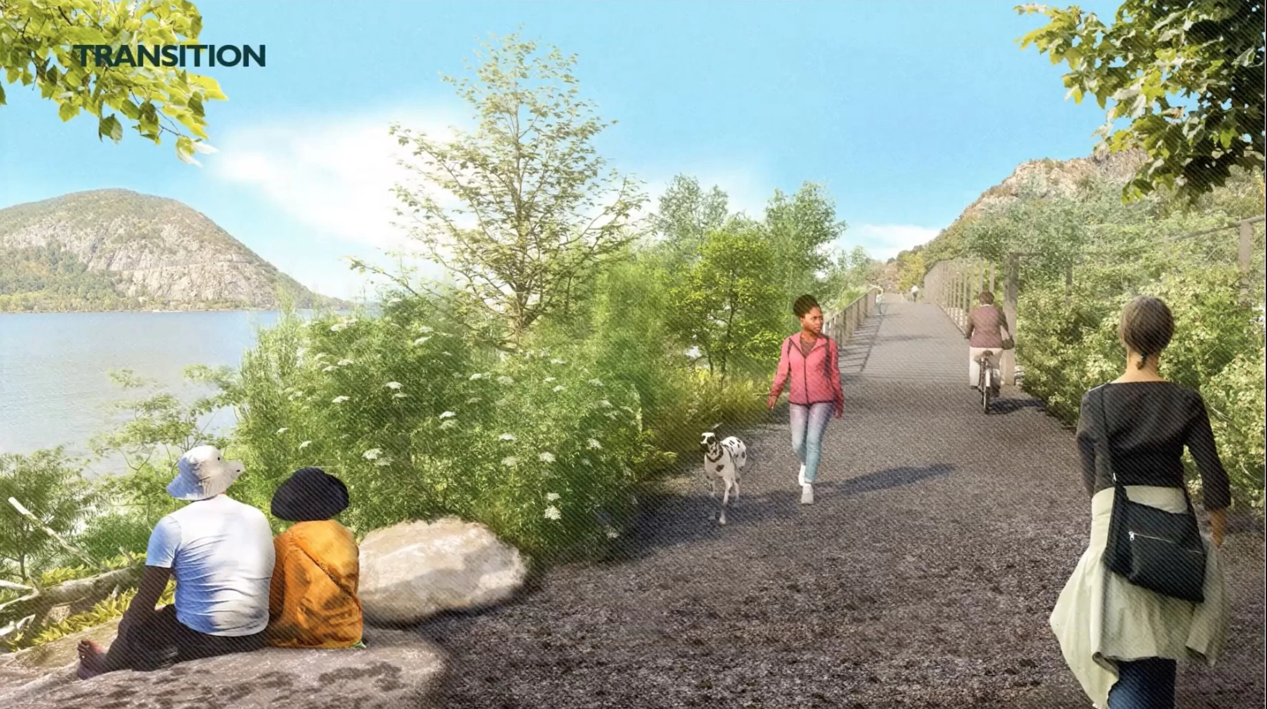
The project’s landscape architect provided these images to give people an idea of how the "trail" might look. The Fjord Trail wouldn’t have the same height, but it shows the same elevated boardwalk on a single pile system.

This is a cross-sectional schematic of the Fjord Trail boardwalk. It shows precast concrete decking 6 inches thick mounted on a concrete girder, which sits on steel piles driven into the shoreline.

This diagram from the designs shows the 8 foot chain link fence used to separate the trail from the tracks for the sections where it’s not integrated with the trail structure.
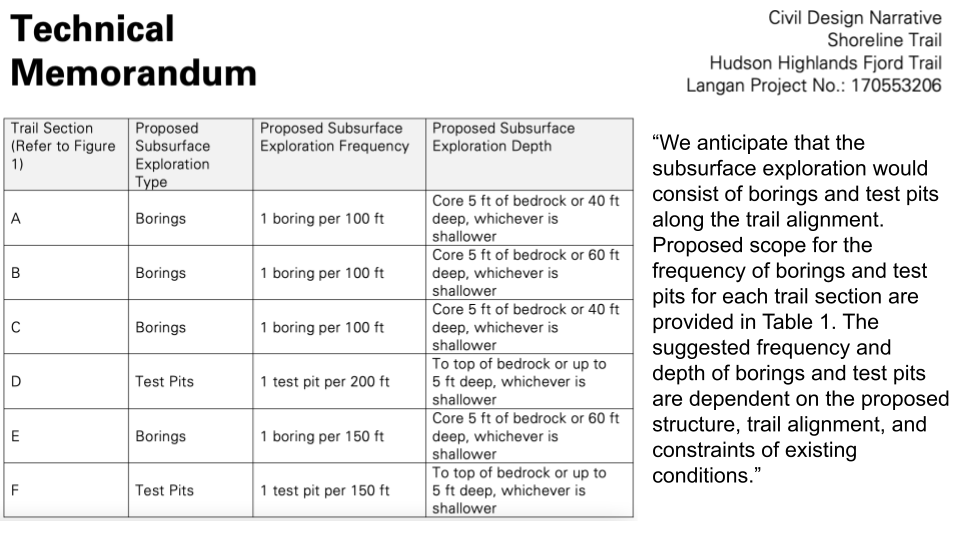
Is it even feasible to build? This table from the project's engineers shows they need to do test bores every 100 feet along the rip-rap shoreline. They would require permits from the DEC to do these test borings and haven’t done them yet.
When the trail reaches Breakneck Ridge and the tracks go into the tunnel, the trail makes its most grotesque assault on the landscape.

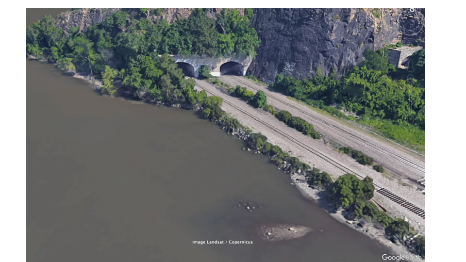
Here’s the shoreline around Breakneck Ridge as it exists today. Notice the lush vegetation along the river's edge.

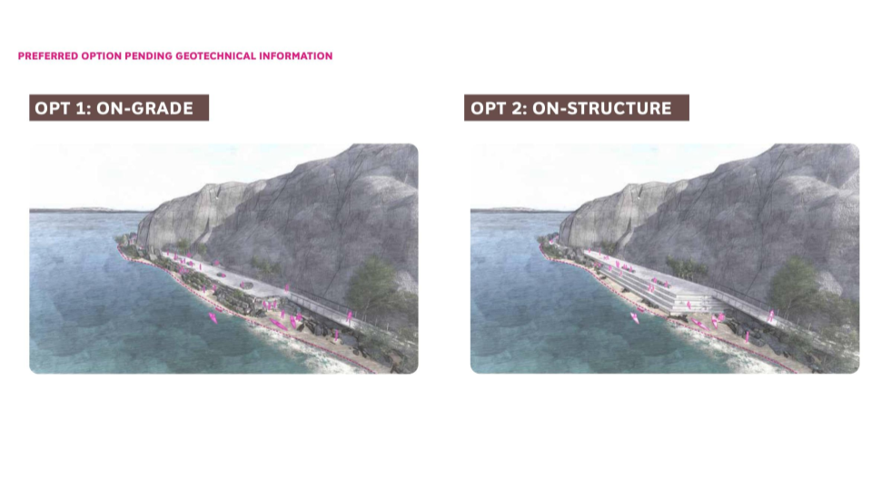
Here’s a diagram from a Scenic Hudson presentation showing a completely transformed shoreline, denuded of almost all vegetation and with large concrete structures in its place.
Here are a couple of renderings of what this might look like when viewed from the south.

This rendering from the landscape architect’s website looks remarkably similar (image © SCAPE). Here they're proposing to transform a former industrial site in Staten Island, whereas in our case it's to transform one of the most iconic and sublime views along the Hudson Valley.

Scenic Hudson will dismiss those renderings as ideas they were brainstorming, but here are the actual design schematics. You now know how to recognize tree removal, clearing, and grubbing. The area would be almost completely cleared of vegetation.

This shows the extent of the construction within that area. On the right, they reference the “pre-cast concrete plank trail”. In the middle there’s “stone quarried block on precast concrete structure on piles,” and on the left there’s “stacked landscape boulders."

Here’s a cross-sectional view or the proposed Breakneck Lower Overlook to really drive home that this is not the trail "envisioned by locals to manage visitation and respect the landscape" (source: https://hhft.org/).

From the overlook, the proposed trail continues north around the point to connect to a new bridge over the train tracks just north of the Breakneck tunnel.

This iconic view will be lost. We must not let this happen.
Images from HHFT's updated designs (Jan 2024) are provided below. They reflect a significant backing away from certain elements of their original designs. We'll provide commentary on the new designs when we get more details.